
Building in a floodplain in Wichita is allowed, but the rules change the house. You need a Floodplain Development permit before any work starts. The lowest floor, including a basement, has to sit at least 2 feet above the Base Flood Elevation. In a market where nearly every new home has a basement, that one rule can decide the foundation, the floor plan and the storm shelter. Check the flood map before you buy the lot and before a single room is drawn.
This guide to building in a floodplain in Wichita covers how to check a lot, what the City of Wichita and Sedgwick County require, and how a designer adjusts the plan. Flood maps and ordinances are updated from time to time, so confirm current rules with the Metropolitan Area Building and Construction Department (MABCD) at 316-660-1840.
Step 1: Check the map
- Search the address at the FEMA Flood Map Service Center, which FEMA describes as the official public source for flood hazard information.
- Open the Sedgwick County GIS land records map and turn on the Flood Plain layer.
- Ask MABCD’s floodplain staff to confirm the zone and the Base Flood Elevation for the parcel.
- Note the effective date of the map panel. New maps can move a line across a lot.
Flood terms on a site plan
| Term | Meaning |
|---|---|
| Special Flood Hazard Area (SFHA) | Land with a 1 percent chance of flooding in any year, often called the 100-year floodplain |
| Base Flood Elevation (BFE) | The height floodwater is expected to reach in that 1 percent flood |
| Zone AE | SFHA where a BFE has been determined |
| Zone AO | SFHA with shallow flooding shown as a depth, not an elevation |
| Floodway | The channel and the land next to it that must stay open to carry floodwater |
| Freeboard | Extra height required above the BFE as a safety margin |
| Elevation Certificate | A form completed by a surveyor, engineer or architect that records the building’s elevations |
What the local rules require
The numbers below come from the City of Wichita floodplain ordinance (City Code Chapter 27.06) and the Sedgwick County floodplain resolution (County Code Chapter 13).
| Rule | City of Wichita | Unincorporated Sedgwick County |
|---|---|---|
| Permit before any development in the SFHA | Required | Required |
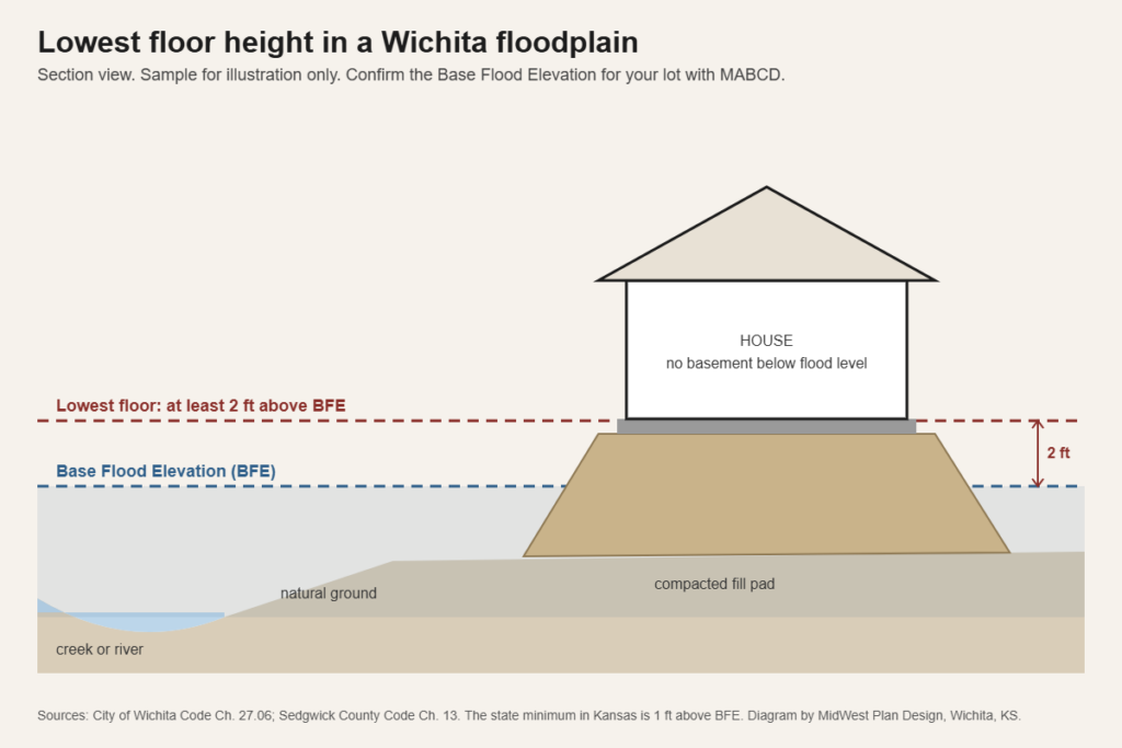
| Lowest floor of a house, including basement | At least 2 feet above BFE | At least 2 feet above BFE |
| Where no detailed flood study exists | Ask MABCD | 3 feet above the estimated BFE |
| Zone AO | 2 feet above the depth number on the map, or 3 feet if no number is given | See county resolution |
| Floodway | No encroachment, including fill, without a no-rise analysis | No-rise certification required |
| Proof | Lowest floor certified by a licensed land surveyor or professional engineer | Same |
Kansas regulations set the statewide minimum at 1 foot above BFE, so the local 2-foot standard is stricter than the state’s.
The permit
MABCD uses Form 76, the Floodplain Development Permit Application. Development is defined broadly. It includes fill, grading and driveways, not only buildings. MABCD’s floodplain page notes that permits from the Kansas Division of Water Resources, the U.S. Army Corps of Engineers or the Kansas Department of Health and Environment may also be needed.
How building in a floodplain in Wichita changes the house design
The basement
FEMA’s rule is that the lowest floor of a house, including the basement, must be above the BFE, and basements below the BFE are allowed only in communities with a special exception. In practice, building in a floodplain in Wichita means no conventional basement on the part of the lot inside the flood zone. That changes three things:
- Foundation. The house sits on a raised slab, a crawl space or a fill pad built up above the required elevation.
- Square footage. Space you expected to finish downstairs has to go on the main level or a second story. Compare the options in ranch vs two story.
- Storm shelter. Without a basement, plan an above-ground safe room. See storm shelter house plans in Wichita.
Fill
Raising the building site with fill is common, and it is regulated. State rules treat material averaging more than 1 foot above existing ground as a floodplain fill. Fill is not allowed in a floodway without an engineer’s analysis showing it will not raise flood levels.
Placement on the lot
Often only part of a lot is in the SFHA. Moving the house to the high side can take the building out of the flood zone entirely. That is a site plan decision, and it should be made before the floor plan. Our guide on how to read a site plan shows where flood lines and floor elevations appear. On rural tracts, the well and sewage system have to stay clear of the flood zone too. See building on acreage near Wichita.
Equipment and garages
Plan to keep the furnace, water heater and electrical panel above the required elevation. Ask MABCD how attached garages and accessory buildings are treated on your lot.
Where flooding comes from around Wichita
The Arkansas River, the Little Arkansas River and creeks such as Cowskin, Gypsum and Chisholm drain the metro area. The Wichita-Valley Center Flood Control Project, known locally as the Big Ditch, was built from 1950 to 1959 with the U.S. Army Corps of Engineers. A county document describes the project as having 40.9 miles of channels and 97 miles of levees. It carries high water around the west side of the city.
Flood control lowers risk. It does not remove mapped floodplain. The U.S. Geological Survey documented a major flood on Cowskin Creek on October 31, 1998. Lots along creeks on the west side and near the rivers still fall in flood zones.
If the map looks wrong
Flood maps are drawn at a large scale and sometimes include high ground by mistake. FEMA can issue a Letter of Map Amendment (LOMA) when a property was mapped in the floodplain but is on natural ground above the BFE. A surveyor provides the elevation data. FEMA does not charge a fee to review a LOMA. A lot raised with fill goes through a different process, a Letter of Map Revision based on Fill, and FEMA charges for that review.
An Elevation Certificate by itself does not remove the flood insurance requirement. Only a LOMA or LOMR-F changes the map.
Before you buy: a short checklist
Anyone considering building in a floodplain in Wichita should have these five items in hand before closing on a lot.
- Flood zone and BFE confirmed in writing.
- How much of the lot is outside the SFHA and the floodway.
- Elevation of the natural ground from a surveyor.
- A flood insurance quote for the planned house.
- A sketch from a designer showing that the house you want fits on the high ground.
Frequently asked questions
Can I build a house on a flood plain?
Yes, outside the floodway, with a Floodplain Development permit and the lowest floor at least 2 feet above the BFE in Wichita and unincorporated Sedgwick County.
Is it worth building a house in a flood plain?
For building in a floodplain in Wichita, it depends on how much of the lot is affected. If the house can sit on high ground outside the flood zone, the impact is small. If the whole lot is in the SFHA, expect no basement, added site work and flood insurance.
Why should people not build in flood zones?
Because of flood risk to the house, limits on basements and fill, and the continuing cost of insurance. Those are reasons to check first, not always reasons to walk away.
Sources
- Floodplain management, MABCD
- City of Wichita floodplain management ordinance 50-381
- Floodplain Development Permit Application, MABCD Form 76
- FEMA Flood Map Service Center
- Basement, FEMA glossary
- Letter of Map Amendment, FEMA glossary
- Flood on Cowskin Creek, U.S. Geological Survey
Have the lot checked before you design
MidWest Plan Design prepares residential site plans and house plans that account for flood lines from the first sketch. Gary Wilbert has more than 30 years of residential design experience. Call 316-806-2492 or request a consultation with the address of the lot.