
To read a site plan, start at the edges and work in: find the north arrow and scale, trace the property lines, then locate the setback lines, easements, house footprint, utilities, drainage arrows and driveway. A site plan is a top-down drawing of the whole lot, and every line on it answers one question: can this house legally and physically sit here?
This guide shows how to read a site plan using a sample drawing with nine numbered callouts. The same steps work on a builder’s plot plan, a surveyor’s drawing or the site plan in a permit set for the Metropolitan Area Building and Construction Department (MABCD).
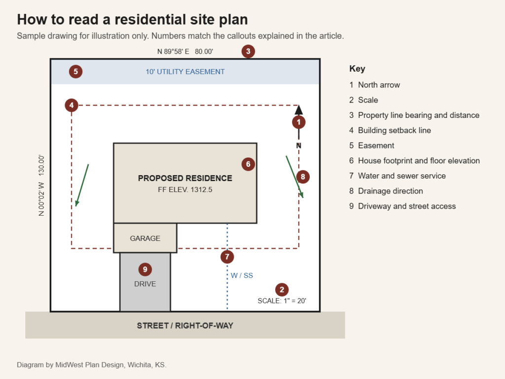
How to read a site plan in nine steps
1. North arrow
The north arrow tells you how the drawing is turned. North is often up, but not always. Once you know north, you know which rooms get morning sun and which wall takes the south wind in summer and the north wind in winter. In Wichita that matters for the garage door, the patio and the west-facing windows.
2. Scale
Site plans use an engineer’s scale. A note such as 1 inch = 20 feet means one inch on paper equals 20 feet on the ground. On the sample, the 80-foot lot width measures 4 inches. Never scale a printed plan that has been resized or photographed. Use the written dimensions.
3. Property lines, bearings and distances
Property lines are the heaviest lines on the sheet. Each one carries a bearing and a distance, for example N 89°58′ E 80.00′. The bearing is a compass direction: start facing north, turn 89 degrees 58 minutes toward the east. The distance is in feet and decimals of a foot, not feet and inches. A line marked 130.50′ is 130 feet 6 inches long.
These numbers come from the recorded plat or a boundary survey by a Kansas licensed land surveyor. A site plan drawn without them is a sketch.
4. Building setback lines
Setback lines are dashed lines inside the lot. They mark the minimum distance the house must stay from each property line. In Wichita’s SF-5 district the base standards are 25 feet in front, 20 feet in back and 6 feet on interior sides. The space inside the dashed lines is the buildable area. Our guide to Wichita residential setback requirements lists the numbers by district.
Look for the abbreviation B.S.L. or the words building setback. If the plat shows a deeper setback than the zoning code, the plat controls.
5. Easements
An easement gives someone else the right to use part of your lot. The sample shows a 10-foot utility easement along the rear line. Common labels are U/E for utility easement and D/E for drainage easement. You own the ground, but you cannot put the house on it, and a fence or shed there can be removed if a utility needs access.
6. House footprint and floor elevation
The footprint is the outline of the foundation, including the garage and covered porches. Dimension lines run from the footprint to the property lines. Those distances must be equal to or greater than the setbacks.
The label FF ELEV. gives the finished floor elevation in feet above sea level. The sample reads 1312.5, which is typical of ground elevations in the Wichita area. Builders compare this number to the street and the surrounding grade to make sure water runs away from the house and the driveway is not too steep.
7. Utilities
Utility lines are usually dotted or dashed and labeled with letters. W is water, SS is sanitary sewer, G is gas and E is electric. The site plan shows where each service enters the lot and reaches the house. On a rural lot, this is where you will see the well, the septic tank and the lateral field or lagoon.
Before anyone digs, Kansas law requires a locate request through Kansas 811 at least two full working days ahead.
8. Drainage and grading
Arrows show which way surface water flows. Contour lines, if shown, connect points of equal elevation. Lines that are close together mean a steep slope. Lines that are far apart mean flat ground. Flat lots are common in Sedgwick County, so a few inches of fall drawn correctly can decide if the backyard drains or ponds.
Check whether any part of the lot falls in a mapped floodplain. FEMA’s Flood Map Service Center shows the zones, and MABCD has a floodplain technician at 316-660-1840.
9. Driveway and street access
The driveway connects the garage to the street across the public right-of-way. The plan shows its width, where it meets the street and how far it sits from the lot corner. Corner lots have extra rules, covered in how corner lots can affect home design in Wichita. On acreages, MABCD routes road and driveway approval to the Sedgwick County Fire Department when any part of the structure is more than 200 feet from a road.
Common site plan abbreviations
| Abbreviation | Meaning |
|---|---|
| P/L or PL | Property line |
| R/W or ROW | Right-of-way |
| B.S.L. | Building setback line |
| U/E | Utility easement |
| D/E | Drainage easement |
| FF or FFE | Finished floor elevation |
| SS | Sanitary sewer |
| W | Water line |
| P.O.B. | Point of beginning |
| CL | Centerline |
Abbreviations vary by firm, so check the legend on your own sheet.
Site plan, survey, plot plan and plat: what is the difference?
| Document | Who prepares it | What it is for |
|---|---|---|
| Plat | Surveyor or engineer for the developer, recorded with the county | Creates the lots, streets, easements and platted setbacks |
| Boundary survey | Kansas licensed land surveyor | Locates the actual corners and lines of one lot |
| Site plan or plot plan | Home designer, builder or engineer | Shows the proposed house on the lot for design and permit |
| Mortgage inspection | Surveyor for a lender | A limited check for closing, not for building |
A site plan depends on the first two. If the plat and survey are wrong or missing, the site plan cannot be trusted. See from Wichita property survey to custom house plan.
What MABCD looks for on a residential site plan
MABCD asks applicants to bring a site plan, the legal description and the parcel identification number when applying for a residential permit in Wichita or unincorporated Sedgwick County. Reviewers want to see the lot dimensions, the house location and the distances to each lot line. Knowing how to read a site plan lets you check those items yourself before the permit appointment. Our guide to Wichita building permit plans covers the rest of the submittal, and building a house in Sedgwick County covers wells, septic systems and lagoons.
Five mistakes to catch before you sign off
- The house is dimensioned to the curb, not the property line.
- An easement from the plat is missing.
- The covered porch or deck crosses a setback line.
- The finished floor is lower than the street with no drainage plan.
- The driveway slope was never checked against the garage floor height.
Our article on how site conditions can affect your residential site plan explains slope, soil and drainage in more detail.
Frequently asked questions
What does a scale reading 1″=20′ on a site plan mean?
One inch on the drawing equals 20 feet on the ground. A house that is 60 feet wide measures 3 inches on the sheet.
What are the five key features of a site plan?
Property lines with dimensions, the building footprint with setbacks, easements, utility connections, and driveway access. Grading and drainage are a close sixth.
How do you read and interpret plans?
Read the title block, legend and scale first. Then find north, trace the outer lines and work inward to the details. Notes on the sheet override anything you measure with a ruler.
Is a site plan part of a set of house plans?
Usually, yes. It is one of the sheets described in what is included in a set of house plans.
Sources
- MABCD permits, Sedgwick County
- Wichita-Sedgwick County Unified Zoning Code, Municode
- Kansas Corporation Commission, call 811 before you dig
- FEMA Flood Map Service Center
- City of Wichita GIS map search
Need a site plan for a Wichita lot?
MidWest Plan Design prepares residential site plans for homeowners and builders in the Wichita area. Gary Wilbert has more than 30 years of residential design experience. Call 316-806-2492 or request a consultation and have your plat or survey ready.
One Response